So it's important to redefine the conventional notion of Parramatta CBD. It needs to be more than a highrise zone around a single train station. It needs to incorporate diverse and vibrant precincts in the same way Sydney CBD has districts like Ultimo, Pyrmont, Darlinghurst that add character to the high rise business core.
The catch is therefore broadening out the definition of Parramatta CBD to the corridor contained within the "city circle" of train stations between Westmead, Strathfield and Rhodes:

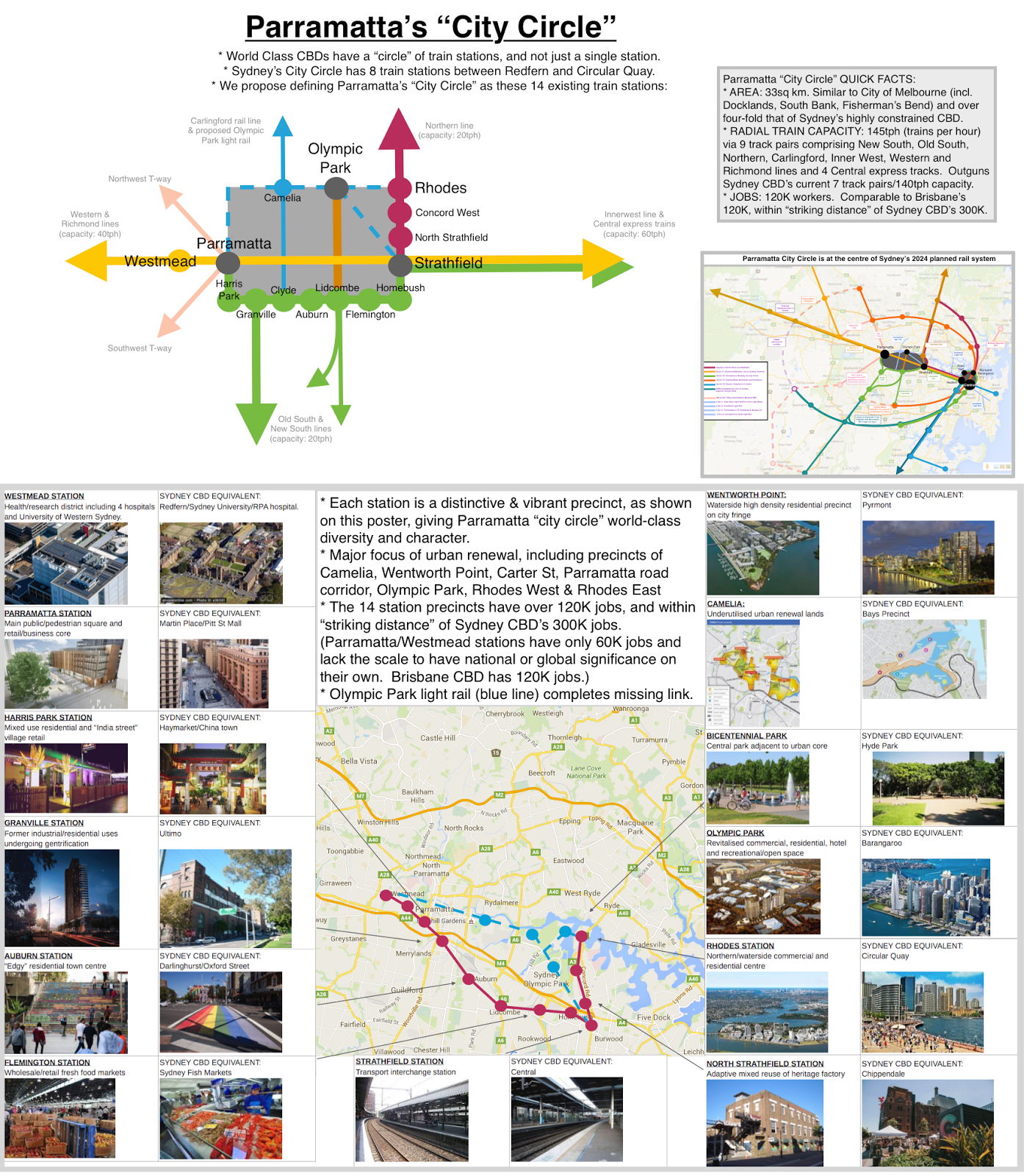
This definition is important, as Parramatta station precinct on it's own is not in the "world class" league. However, Parramatta "city circle" is clearly world-class as highlighted in the poster below:

High resolution version can be viewed at this link. As seen in the poster, each of the station precincts within Parramatta "city circle" adds diversity ranging from food markets at Flemington, to the high interconnected railway interchange at Strathfield, adaptive heritage reuse at North Strathfield, the "Little India" retail at Harris Park, Millenium Parklands at Wentworth Point, extensive cycle routes and the recreational/office/hotel/sports mixed uses at Olympic Park.
Some quick facts about Parramatta city circle:
* Jobs: 120K jobs, making it the third largest CBD in Australia. Sydney CBD is ranked first with 300K jobs and Brisbane is equal third ranked with 120K jobs.
* Train stations: 14 heavy rail stations from Westmead to Strathfield along east-west axis, and to Rhodes in the north. In comparison, Sydney city circle has 8 heavy rail stations between Redfern and Circular Quay (and another two new stations planned for Sydney Metro at Barangaroo and Pitt St).
* Train capacity: 145tph (trains per hour). Has nine radial track pairs, comprising two lines from south (Old South, New South), two lines from the north (Northern, Carlingford), two lines from the west (Western and Eichmond) and six tracks from the east (Inner west line and four Central station express tracks). This outgun's Sydney CBD's seven track pairs and current 140tph capacity.
* House prices: comparing suburbs within 10km of each CBD, Parramatta is one third the price of Sydney (Blacktown 2015 median house price of $620K vs Randwick 2015 median house price of $1.8 million).
* Area: approximately 10km x 3km = 30sq km. In comparison Sydney's city circle from Redfern to Circular Quay measures 4.5km x 1.5km = 7sqm km, or one quarter the size of Parramatta city circle's land area. This makes Parramatta city circle more dispersed than the highly compact Sydney CBD, but still a reasonable "sizing outcome" as Sydney CBD is considered to be highly land constrained and has limited future capacity as a result. Parramatta city circle's four-fold greater size allows "blue sky" growth for decades to come whilst still retaining sufficient compactness and density for the benefits of agglomeration and public transport effectiveness. The combined areas of Melbourne's CBD, Southbank, Docklands, Fisherman's Bend and East Melbourne districts roughly matches the area of Parramatta city circle.
As seen in the 2024 Rail Diagram below, Parramatta city circle is at the entire of the entire Greater Sydney rail network as currently planned (ie: comprising existing rail lines, under construction rail lines, plus officially reserved rail corridors):

This is a poster that incorporates all the above images into a single sheet:
No comments:
Post a Comment