Former industry minister Ian Macfarlane and Australian Prime Minister Malcolm Turnbull were previously good friends and close allies. In 2009, Macfarlane was a Turnbull backer in the leadership spill between Turnbull and Abbott. Macfarlane was also Turnbull's key negotiator with the Labor Party over climate change policy. This suggests between 2007 and 2009, Macfarlane switched from being a climate skeptic into a climate believer.
This week we discover Macfarlane proposes to switch over to the National party, apparently over dissatisfaction over being dumped from the ministry. Is Macfarlane now back to being a climate change skeptic like the rest of the National Party? The superficial interpretation of these events may indeed be true and the events of this week may have blindsided Turnbull.
But let's come up with some "left field" alternative scenarios. Assume Turnbull is a strategic genius (like his historical perceptiveness in relation to China and the Thucydides trap). Could he have masterminded a switch of his ally Macfarlane over the National party? Macfarlane then is in a position to take up leadership of the National party on retirement of current leader Warren Truss. He then modernises the National party and purges it of some of it's science denying elements. Macfarlane can also negotiate a new coalition agreement which frees Turnbull from policy restrictions which the current one imposes. Turnbull post 2016 elections (assuming he wins the election) is then in position to overhaul the Liberal-National party climate policies.
Friday, 4 December 2015
Thursday, 3 December 2015
Saturday, 31 October 2015
Orbital network: Hornsby to CBD in 25 minutes
Continuing on the theme of comparing "orbital" versus "grid" routes taken in the previous post, consider also the Hornsby to Sydney CBD journey. This journey is important not just for the Northern suburbs of Sydney, but also for Central Coast and Newcastle commuters and also "reverse commuters" coming from other parts of Sydney to employment zones like Chatswood and Macquarie Park. Reducing journey times of the Hornsby to CBD segment would have widespread benefits.
For the case of Macquarie Park, particularly unhelpful is the huge deviation to the north (as far as Lindfield) taken by the Epping to Chatswood link (ECRL), just prior to the junction with Chatswood. This has been panned by numerous observers as a shambolic debacle. However, as we shall see later, this deviation may prove to be a "saviour" in cutting down the Hornsby to CBD journey time from over 40 minutes to 25 minutes or less.

Post commissioning of Sydney Metro Northwest in 2019, the two main routes from Hornsby to Wynyard will be either via the North Shore line ("orbital" route) or via Strathfield ("grid" route). Let's compare these two routes:
Friday, 30 October 2015
Orbital network: "spider-web" versus "grid"
Sydney's key economic corridors follow an orbital pattern, and it's rail network has a "spider-web" organisation. The diagram below looks at an example comparison of travel distances for the spider-web type of network versus a grid based network:

So some conclusions from the example above are that where the orbitals are elliptical, with a stretched out east-west axis then east-west travel times along the orbits are very competitive with the more "direct" grid network route. However, travel along the short axis (ie: north-south axis) can be quite uncompetitive. For this reason, the spokes of the spider web network should focus on north-south connectivity.
Greater Sydney's rail network (as planned for 2024, plus reserved corridors - see below) is an excellent example of these principles:
Tuesday, 20 October 2015
Parramatta city circle: comparison with Simpson's 'Yamonote'-like circle
Rod Simpson last year presented the idea of a Yamonote-like metro circle for Sydney. The key idea of his circle was to link up key centres in Sydney's north and central regions into a circle, such that anyone having access to one point on the circle can gain access to the the major facilities around the entire circle:


This year Rod Simpson has demonstrated thought leadership in relation to the Parramatta to Olympic Park & Strathfield light rail. This blog has taken up the cause of the latter idea, but substantially reworks the former idea of the Yamonote circle for Sydney and instead proposes the concept of inner & middle ring orbitals.
Why is the Yamonote idea flawed? For these reasons:
Sunday, 11 October 2015
Parramatta city circle: MacPark/Global Economic Corridor as "middle ring"
Malcolm Turnbull has announced Federal funding for an extension of the Gold Coast light rail.
In NSW the top two candidates for the next light rail line (amongst an original short list of four routes) are Parramatta to Olympic Park and Parramatta to Macquarie Park. At the moment, there is an intense competition between these two routes for which one gets funded and proceeds. Could further Federal funding for light rail make it possible for both routes to proceed?
This blog has argued the Olympic Park route should have priority, on the basis of the CBD-scale urban regeneration and land-value capture possible there. On the other hand, Macquarie Park should first implement parking levies to bring it into competitive neutrality with other employment centres like Parramatta and North Sydney before it gets any more government funded infrastructure. TfNSW's 2031 travel modelling shows very little justification for the MacPark to Parramatta connectivity. In contrast, TfNSW projections for travel between Parramatta to Olympic Park are an order of magnitude greater than Parramatta to MacPark:
Thursday, 1 October 2015
Parramatta's "city circle": world class ring of CBD train stations
Parramatta CBD is so much overshadowed by the Sydney CBD that it's characteristics as a CBD in it's own right are under-appreciated. I believe the biggest reason of the "under-marketing" of Parramatta CBD is that it is seen only through the lens of the high rise building zone around Parramatta railway station - whereas both Melbourne and Sydney CBD have the concepts of a "city circle" or "city loop" of 8+ train stations. Also, the boundaries of the Parramatta local government area are nonsensical, incorporating suburban areas far to the north of Parramatta River (bordering onto Hornsby LGA) whilst missing out on immediately adjacent employment zones like Silverwater and Olympic Park that are south of Parramatta River.
So it's important to redefine the conventional notion of Parramatta CBD. It needs to be more than a highrise zone around a single train station. It needs to incorporate diverse and vibrant precincts in the same way Sydney CBD has districts like Ultimo, Pyrmont, Darlinghurst that add character to the high rise business core.
The catch is therefore broadening out the definition of Parramatta CBD to the corridor contained within the "city circle" of train stations between Westmead, Strathfield and Rhodes:
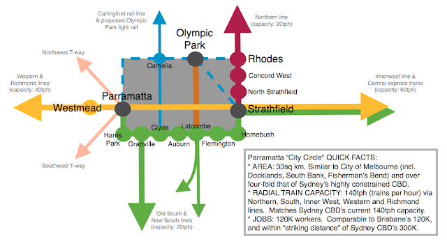
This definition is important, as Parramatta station precinct on it's own is not in the "world class" league. However, Parramatta "city circle" is clearly world-class as highlighted in the poster below:
Wednesday, 30 September 2015
Tax reform: investment neutrality
The tax system distorts investment decisions. On the other hand, some forms of investment have a "positive externality" spill over into the welfare of society and rightly should attract concessions. The aim of tax reform should be to have the greatest possible degree of tax neutrality once positive externalities have been taking into account.
Most current tax subsidies (superannuation, negative gearing, franking) favour mature, and generally income generating investments over early stage growth investments. The cost of superannuation tax concessions alone costs $25 billion per year and is growing rapidly.

To incentivise growth, the tax subsidies need to be recast. Close off loop holes for mature stage investments that can stand on their own two feet. Then provide tax incentives to grow early stage investments like IT & biotech that at $2.5b per year are a drop of water compared to the ocean of superannuation and property investments. These tax incentives need to be targeted yet not be so complex or specific it amounts to "picking winners".
Sunday, 6 September 2015
Sydney Metro: 2036 projection calls for Liverpool extension
The last post looked at current 2014 and projected 2024 rail system patronage and capacity numbers.
Below are projections out to 2036. A simple across the board 3% growth rate has been used on the basis of the "KISS" (Keep it Simple, Stupid) strategy. (Explanations for each of the columns as per previous post: Sydney Metro: 2024 patronage projections & it's hidden "West Metro" branch).
This is because local suburb-by-suburb rezonings and developments are just rounding errors in overall rail system growth rates. For a land use change to have dramatic effects on growth rate on a line, it needs to be "CBD scale" or a cluster of strategic centres, or a very large scale land release over many years. (To put the latter into context in a simplistic manner, the 20+ years of large scale land release across the Northwest from Cherrybrook through to Rouse Hill translates into patronage of the order of an extra 10,000 peak hour pax, or 12.5% of total North Shore/NWRL rail patronage).

Nomenclature of sectors above:
Sector F0 = Northern line's freight/intercity tracks (also services upper northern stations north of Epping). Terminates at Strathfield platform 1.
Sector T0 = Epping to North Shore on dedicated northern line tracks (post quad Strathfield to Epping), then via Harbour bridge. (Upper northern line stations remain in F0)
Sector T1 = Western express tracks to central
Sector T2 = Merrylands to Inner west, Airport and Revesby
Sector T3 = Sydney Metro, extended to Liverpool via Bankstown Airport, then taking over Cumberland line to Guildford, & continuing to Blacktown via Parramatta
Sector T4 = Illawarra main tracks to ESR
Wednesday, 2 September 2015
Sydney Metro: 2024 patronage projections & it's hidden "West Metro" branch
I've been building a patronage and capacity model. This model covers the years 2014, 2024, 2036 and 2049. First let's look at the 2014 rail system numbers, and my projections for 2024. I've taken a pretty simplistic approach of just taking the 2006-2014 compound annual patronage growth rates and projecting these out to 2024, but this more or less aligns with TfNSW's line-by-line growth projections to 2019 (they use a slightly higher growth rate for the Western line).
Some more specific notes to explain the tables below:
1. Baseline 2014 data: taken from TfNSW Bureau of Travel Statistics train station barrier counts.
2. Forecast 2024 data: projected from 2014 data using historical growth rates 2006-2014.
* NWRL data taken from TfNSW projections and added to North Shore & NWRL 2014-2024 growth rate.
3. AM peak entries: apply to the period 6am to 9:30am.
4. Suburban transfers/exits: see explanatory note after tables.
5. Peak Pax to Capacity Ratio: interpretation is as follows
* ratio ~ 0 to 1: well below capacity even during peak hour (8am-9am)
* ratio ~ 1 to 2: at capacity during peak hour, spare capacity in shoulder periods of AM peak
* ratio ~ 2 to 3: at capacity during peak hour & during shoulder periods of AM peak
* ratio ~ 3+: exceeds capacity even in shoulder periods
Ok, here are my spreadsheet tables for 2014 & 2024. (Future post will cover 2036 & 2049).

Some interesting details discussed below are the following:
1. Sydney Metro already has a hidden "West Metro" branch
2. The critical role of suburban interchange at Strathfield in balancing overall system patronage.
Tuesday, 1 September 2015
Sydney Metro extension to Liverpool: system-wide consequences
Liverpool council has called for Sydney Metro to continue to Liverpool, instead of current plans to terminate at Bankstown.
This idea seems simple on the surface, but it will have system-wide consequences on deeper examination. Are these system-wide consequences positive or negative? After extensive thought, my conclusion is that an extension to Liverpool (using a direct route via Bankstown Airport) will be a game-changer for Sydney Metro, and make it arguably the most important line by far in all of Sydney's rail network.
This is all without any further branching of Sydney Metro, an idea I've over time shifted to become less in favour of. In fact, branching would be highly undesirable and a single unbranched line will provide supreme benefits of simplicity, high frequency and reliability whilst being a good match for the increased capacity requirements of serving Liverpool.
The key to why the Liverpool extension has such system-wide implications is what happens to the Cumberland line. Given it's continuity with the Liverpool extension of Sydney Metro, it makes sense to incorporate at least part of the Cumberland line into Sydney Metro as well. This would bring Sydney Metro connections to Parramatta (a key centre that currently does not have Sydney Metro access). The result is shown in the rail diagram below (which also contains other rail plan ideas, but of main relevance to Sydney Metro is the Sector T3 orange curve).

As seen above, incorporating the Cumberland line into Sydney Metro will finally allow rationalisation of the complex interactions of the Cumberland line with Sector T2's Innerwest & South line. What are these interactions? There is a tension between whether the stations from Liverpool to Merrylands should have single seat (ie: interchange free) access to Parramatta CBD or to Sydney CBD. As a result, rail planners have tried to do both by having Cumberland line and Sector T2 share tracks up to Merrylands, where the former branches west (via Harris Park) and the latter to the east (via Granville). This has resulted in compromised frequency and increased complexity for both lines. The lack of frequency is a major problem, as with wait times of 15-30 minutes, the Cumberland line is an unattractive option compared to just using interchange at Granville. Likewise, the inner west line only offers frequency of 4-6 trains per hour at Newtown, which is unsatisfactory.
Friday, 10 July 2015
Parramatta Centric Revisualisation: Geographical Accuracy
Key features of the Parramatta Centric revisualisation of Sydney's rail network are the middle and outer orbitals centred on Parramatta. These orbitals were diagrammatically shown as ellipses. However, as seen in the map below, this is surprisingly accurate geographically, as key railway stations and centres are located very close to a "best fit" ellipses drawn through them. The long axis of these ellipses is restrained to perfect east-west by my drawing program, and it may be that the fit would be even better if there was a slight rotation to the ellipses. Either way the fit is very good:


Friday, 3 July 2015
Parramatta Centric Revisualisation: "City Circle" equivalent
The previous blog post outlined a revisualisation of the rail network with Parramatta at the centre. It also identified an outer orbital and also a middle ring orbital. But in Parramatta's case, does it have an inner orbital? Is this a "missing link" in the network.
In the case of Sydney CBD, a inner orbital is formed by the "city circle", ie: Sydney CBD does not comprise a single station but instead has a number of stations linked into a "circle". So what is Parramatta's equivalent of a city circle?
After some thought, it's clear that the inner orbital for Parramatta comprises:
* Western rail line from Westmead to Strathfield
* Northern rail line from Strathfield to Rhodes
* Olympic Park reserved light rail corridor (currently bus route)
* Olympic Park heavy rail station
This is now what the resulting three orbitals look like:

This now completes the Parramatta-centric rail network. The outer orbital comprises mainly double deck heavy rail. The middle orbital is Sydney metro for the most part although the section around Blacktown is a bus link/T-way. The inner orbital is then predominantly the Olympic light rail reserved corridor. The previous situation of radial lines not quite converging on Parramatta is also now resolved, in that they now converge on the Parramatta city circle.
In the case of Sydney CBD, a inner orbital is formed by the "city circle", ie: Sydney CBD does not comprise a single station but instead has a number of stations linked into a "circle". So what is Parramatta's equivalent of a city circle?
After some thought, it's clear that the inner orbital for Parramatta comprises:
* Western rail line from Westmead to Strathfield
* Northern rail line from Strathfield to Rhodes
* Olympic Park reserved light rail corridor (currently bus route)
* Olympic Park heavy rail station
This is now what the resulting three orbitals look like:

Wednesday, 1 July 2015
Parramatta Centric Revisualisation of Rail Network
Parramatta has been made Greater Sydney's dual CBD in the latest Sydney Metro Strategy.
One criticism of the existing Sydney rail network is that it is too Sydney CBD centric and consists mainly of radial lines with poor inter-regional/orbital connectivity.
But this is not so if you revisualise the network (plus officially announced reserved rail corridors and existing rapid bus T-ways) from a Parramatta-centric point of view. As can be seen in the network diagram below, Sydney's rail network forms a very nicely balanced combination of orbital rail routes and radial rail lines around Parramatta at it's centre. Surprisingly, these aren't just fantasy "lines on a map". Already existing (or under construction/reservation) today are a comprehensive and coherent set of inner and outer orbitals plus western, eastern, northern and southern radial lines converging into the vicinity of Parramatta. The missing links are relatively minor.
The yellow central area is the Central Corridor previously discussed on this blog.
Acknowledgements: the diagram below is my realisation of the network, after the initial conception of a Parramatta-centric rail network came from Bob Meyer at Cox Achitecture.

This type of visualisation should be used by TfNSW so as to change it's mindset and paradigm for future transport planning, as well as to educate the public and importantly, developers/business decision makers, on Sydney's transport geography and Parramatta's central role therein.
One criticism of the existing Sydney rail network is that it is too Sydney CBD centric and consists mainly of radial lines with poor inter-regional/orbital connectivity.
But this is not so if you revisualise the network (plus officially announced reserved rail corridors and existing rapid bus T-ways) from a Parramatta-centric point of view. As can be seen in the network diagram below, Sydney's rail network forms a very nicely balanced combination of orbital rail routes and radial rail lines around Parramatta at it's centre. Surprisingly, these aren't just fantasy "lines on a map". Already existing (or under construction/reservation) today are a comprehensive and coherent set of inner and outer orbitals plus western, eastern, northern and southern radial lines converging into the vicinity of Parramatta. The missing links are relatively minor.
The yellow central area is the Central Corridor previously discussed on this blog.
Acknowledgements: the diagram below is my realisation of the network, after the initial conception of a Parramatta-centric rail network came from Bob Meyer at Cox Achitecture.

Sunday, 28 June 2015
Twelve carriage trains part 3: Why East Hills line needs 12 carriage trains
My last blog post anticipated the possibility of why over the next 30 years, the East Hills line, like current plans for the Western line, will need the 50% capacity boost offered by 12 carriage trains (running independently of Revesby all stops trains).
A number of people have said this is overkill. I'm not sure if they have looked at what the Department of Planning want to do out in the southwest.
The following maps would make it obvious why a dedicated 20 train per hour, 12 carriage train service from the South and West of East Hills and Glenfield is going to be needed over the next 30 years:
There is the Southwest growth centre:

Then there is the Glenfield to Macarthur priority urban renewal corridor:

A number of people have said this is overkill. I'm not sure if they have looked at what the Department of Planning want to do out in the southwest.
The following maps would make it obvious why a dedicated 20 train per hour, 12 carriage train service from the South and West of East Hills and Glenfield is going to be needed over the next 30 years:
There is the Southwest growth centre:
Then there is the Glenfield to Macarthur priority urban renewal corridor:
And then if the above weren't enough, then this:
Anyone who looks at the scale of new housing to be released out in the southwest and doesn't think 12 carriage trains going from these areas onto the East Hills line and then to Central must be assuming all the people living here can just drive instead...
Twelve carriage trains part 2: Future option for East Hills/Macarthur line?
I am one of many bloggers who are guilty of toying with the idea of joining the Airport line to Sydney Metro. However, on reflection about the implications of 12 carriage trains for the Sydney network, joining the Airport line to Sydney Metro will not only be disruptive in the short term, it will also be detrimental over the longer term (30yrs+).
This is because of:
1. Loss of opportunity provided by Sydney Metro capacity to establish new branches to other parts of Sydney to the south (Gary Glazebrook made this point recently & I think it is a very good point). Note also the Airport line PPP doesn't expire until 2030, so compensation would be payable to private owners if shutdown and conversion of the line happens before then.
2. The impact on operations of the Inner West line. At present, the two are natural partners and are connected via the City Circle. Disconnect the airport line, and then where would inner west all stops trains go? They can only feed into East Hills line, which is less good a match. Why? This leads me to the next point....
3. Longer term (with growth of housing in the Southwest), commuter style trains like East Hills line will be need the massive (50%) capacity increment and be converted into 12 carriage trains and these trains can't service the inner west line. Think this won't be happen/never be needed? Well it's happening already on the Western Line, as explained in the previous post. This then leads to the next point...
4. Airport line does not need any new/additional CBD access via Sydney Metro. It's current CBD access by the city circle is more than adequate. The problem is that it needs to share this access with East Hills line trains. That may be the case if East Hills uses 8 carriage trains. But if they are converted to 12 carriage trains, then Airport line will have city circle (anticlockwise) all to itself.
OK, what about the issue of trains terminating at Central... is that going to be a problem. I don't think so.... as shown below, only 25% (60 trains out of 240 trains per hour) will terminate at Central. The rest will continue to CBD, with multiple interchange possibilities along both the Western and the East Hill lines.
Sydney Metro = 60 tph
Western/North Shore lines = 70 tph
- West main tracks: 30 tph (8 carriage "equivalents", all terminate at Sydney terminal)
- West suburban tracks: 20 tph
- North Shore: 20 tph
Inner West/Airport/Revesby = 40 tph
- West local tracks: 20 tph
- Revesby/Airport: 20tph
East Hills, Illawarra & ESR = 70 tph
- ESR: 20tph
- Illawarra: 20tph
- East Hills: 30tph (8 carriage "equivalents", all terminate at Sydney terminal)
Total capacity of all the above is 240 trains per hour. Note if East Hills line feeds into city circle instead of terminating at Sydney terminal, then the 30tph extra capacity is lost and system capacity is only 210 tph.
Is 25% of trains terminating at Central too much? I don't think so. It's just the right number, as suggested by the following CBD station exit data:
Central: 21k exits (8am-9am)
Town H: 23k exits (8am-9am)
Wynyard: 22k exits (8am-9am)
Martin place & eastern CC: 18k exits (8a-9am)
ie: Central station exits = 21 / (21+23+22+18) = 25% of all CBD station exits
5. Does Inner west & Airport/Revesby need 20tph? They probably need 8-10tph at present, but in 30yrs with Sydney's population at 8 million people and the trend towards high density apartment living in the inner city, I can easily see them needing 20 tph or more, in which case it is time to convert Inner West & Airport into a metro line and resignal for 30tph.
[Further note: see projections for 2024 patronage - the innerwest line will be one of the most congested lines in the whole rail network]
Twelve carriage trains part 1: West Main line to get 50% higher capacity?
I've already posted abut the $19m budgeted for Western Sydney light rail, which is disappointing given it's been as much as 12 months since all the $400m, $600m, and $1 billion announcements were made. I was hoping by now that TfNSW would have been budgeting for the procurement phase in the next 12 months, rather than another year of the planning phase, but given Sydney Metro has been in "planning" for even longer and is only getting $50m this coming year, it does seem overall that these budget amounts are just very preliminary funds and that big ticket procurement announcements will still be coming in the near future.
However, time to move on and look at the other announcements, which includes:
* $36 for SRF2 (Sydney's Rail Future stage 2)
* $94 million "to continue procurement of the next-generation intercity train fleet"
These are significant amounts, so what is going to happen with these initiatives? The NSW Infrastructure 2014 update to the State Infrastructure Strategy provides some tantalising clues - perhaps more clues than what the secretive TfNSW wanted us to know:
From page 27:
From page 33:
And now specific 2015 NSW Budget line items are provisioning a total of $130m for these initiatives. Of course, readers of this blog would have already know about the 12 carriage trains from the post in December 2014, which looked at internal TfNSW documents demonstrating how 10 carriage Western line trains are some of the most cost effective measures available for increasing capacity. As existing train lengths are 8 carriages, going up to 10 carriages is a 25% capacity increment and the platform lengthening needed was costed at under $300m for key stations along the Western line. Now TfNSW are going even further and looking at increasing capacity by 50% with 12 carriage trains. This should all fit neatly into the $1 billion allocated to SRF2 from poles and wires leasing funds.
Not what did Infrastructure NSW mean by "This is intended to complement the Sydney Rapid Transit project, which is Transport for NSW’s preferred option for addressing constraints between Strathfield and the Sydney CBD". The problem with the 12 carriage trains is that they won't fit into the underground CBD stations as these are only 160m long and restricted to 8 carriage trains. So these trains will need to terminate at Central station (which does have longer platforms at Sydney Terminal). So what will people needing to go to Town Hall or Wynyard do? My blog post speculating on the Sydney Metro design for new Central Station platforms provides an answer: they will likely be able to walk across or walk down to an immediately adjacent Sydney Metro platform and catch a Sydney Metro train from Bankstown into the CBD, which very conveniently will have high frequencies and plenty of spare capacity.
One interesting question would be whether these 12 carriage trains will be single deck or double deck? Double deck seems to fit in better with the "three tier" strategy of differentiating between metro style services (providing faster acceleration and boarding) and commuter style services (providing more seats in double decks). But there are fewer "off the shelf" double deck procurement options for rolling stock, so it could possibly end up as single deck if these prove to be easier to procure. This will be an interesting decision to watch.
However, time to move on and look at the other announcements, which includes:
* $36 for SRF2 (Sydney's Rail Future stage 2)
* $94 million "to continue procurement of the next-generation intercity train fleet"
These are significant amounts, so what is going to happen with these initiatives? The NSW Infrastructure 2014 update to the State Infrastructure Strategy provides some tantalising clues - perhaps more clues than what the secretive TfNSW wanted us to know:
From page 27:
Infrastructure NSW supports the Government’s plans to accommodate growth in rail demand through the implementation of Stage 2 of Sydney’s Rail Future (SRF2). Infrastructure NSW considers that the SRF2 program is being planned thoroughly, has strategic merit and – subject to detailed business case development of its constituent projects – should be a priority for additional investment in Sydney’s rail network. Infrastructure NSW recommends reserving $1.0 billion from the Rebuilding NSW initiative to accelerate the SRF2 program, including the Western Sydney Rail Upgrade Program.
Stage 2 of Sydney’s Rail Future (SRF2), which encompasses the Western Sydney Rail Upgrade Program and procurement of new Intercity rolling stock, focuses on providing greater capacity for the rail network, reducing overcrowding, network capacity constraints, and operational complexity at key points on the network. It is also designed to integrate the North West and South West Rail Links into the wider network. Stages 4 and 5 of Sydney’s Rail Future focus on the extension of the Rapid Transit System to the CBD and Sydney’s south west and south, through the construction of a second Harbour Crossing and a western extension to Bankstown – collectively referred to as ‘Sydney Rapid Transit’.
Delivering network efficiencies: Sydney’s Rail Future Stage 2
SRF2 features a number of separate projects at varying stages of development for implementation over the next decade. The key elements of the program include:
• The Western Sydney Rail Upgrade Program, which includes:
– the T1 Corridor Infrastructure Program, which targets capacity constraints on the Western and Northern Lines (representing 30 per cent of all Sydney rail journeys) by upgrading traction supply, amplifying track and lengthening platforms on the corridor. Demand is forecast to grow faster for the T1 rail lines than for the rail network as a whole – Advanced Train Control, an integrated system for signalling, train protection and train control that focuses on increasing service frequencies and capacity on parts of the network.
• New rolling stock for Intercity services to replace ageing trains and deliver improved reliability and resilience.
The Western Sydney Rail Upgrade Program will deliver civil and electrical infrastructure on the T1 corridor to enable longer (12 car) Intercity trains to operate and to improve the separation of Intercity and suburban services, increasing capacity west of Strathfield. This is intended to complement the Sydney Rapid Transit project, which is Transport for NSW’s preferred option for addressing constraints between Strathfield and the Sydney CBD. In conjunction with Sydney Rapid Transit, the SRF2 program, as currently costed, has an indicative benefit- cost ratio of 1.6.Did you see that? I have highlighted in yellow above "enable longer (12 car) intercity trains". Infrastructure NSW has divulged some of the internal evaluations being done by TfNSW on initiatives like 12 carriage trains for the Western Line. This specific detail is something TfNSW have not disclosed in any of their glossy brochures or in fact that their Sydney Metro community consultation staff seem to be aware of. Yet it seems to be in advanced planning stages, with Infrastructure NSW indicating the business case is sound with a high ratio of benefit to cost.
And now specific 2015 NSW Budget line items are provisioning a total of $130m for these initiatives. Of course, readers of this blog would have already know about the 12 carriage trains from the post in December 2014, which looked at internal TfNSW documents demonstrating how 10 carriage Western line trains are some of the most cost effective measures available for increasing capacity. As existing train lengths are 8 carriages, going up to 10 carriages is a 25% capacity increment and the platform lengthening needed was costed at under $300m for key stations along the Western line. Now TfNSW are going even further and looking at increasing capacity by 50% with 12 carriage trains. This should all fit neatly into the $1 billion allocated to SRF2 from poles and wires leasing funds.
Not what did Infrastructure NSW mean by "This is intended to complement the Sydney Rapid Transit project, which is Transport for NSW’s preferred option for addressing constraints between Strathfield and the Sydney CBD". The problem with the 12 carriage trains is that they won't fit into the underground CBD stations as these are only 160m long and restricted to 8 carriage trains. So these trains will need to terminate at Central station (which does have longer platforms at Sydney Terminal). So what will people needing to go to Town Hall or Wynyard do? My blog post speculating on the Sydney Metro design for new Central Station platforms provides an answer: they will likely be able to walk across or walk down to an immediately adjacent Sydney Metro platform and catch a Sydney Metro train from Bankstown into the CBD, which very conveniently will have high frequencies and plenty of spare capacity.
One interesting question would be whether these 12 carriage trains will be single deck or double deck? Double deck seems to fit in better with the "three tier" strategy of differentiating between metro style services (providing faster acceleration and boarding) and commuter style services (providing more seats in double decks). But there are fewer "off the shelf" double deck procurement options for rolling stock, so it could possibly end up as single deck if these prove to be easier to procure. This will be an interesting decision to watch.
Chinese Infrastructure Investment: Paradigm change?
Two major developments caught my attention this week: firstly the signing of the Chinese-Australia free trade agreement on June 17, and secondly the publishing of a report by KPMG into Chinese investment in Australia.
KPMG's Demystifying China has highlighted the scale and concentration of Chinese property and infrastructure investment into Australia, with NSW receiving 72% of total Chinese investment and Sydney & Melbourne together getting more Chinese investment than London or New York individually.

What has intrigued me is the purchase of local infrastructure builder John Holland by CCCC (China Communications Construction Company). Almost all of Sydney's most significant infrastructure under construction is being built by John Holland. Sydney Metro Northwest? Yep, John Holland. WestConnex M4 East? Yep, John Holland. South East Light Rail? Ok, no, John Holland missed out or didn't want to take up the risks involved. But they did construct the inner west light rail extension. Southwest rail link? Yep, John Holland.
Did CCCC buy John Holland to just take a "hands off" approach? The timing and magnitude suggests not. Firstly magnitude: at a cost of around $1 billion, this is a major investment for a company which has a market capitalisation in China of around $20 billion. Then timing: the acquisition was announced a month after G20 in which a China-Australia free trade deal was announced. Did this timing reflect the raising of the FIRB Chinese investment to $1 billion? No, as CCCC is state owned and therefore would have required FIRB approval regardless - which they did ultimately receive. I believe the timing of this deal reflects provision in the China-Australia free trade agreement for IFAs (Investment Facilitation Agreements). I'm going to quote this excerpt from lawyers KWM to explain:
Whilst not quite bringing Chinese-level wage & employment conditions into Australia, IFAs will allow John Holland to keep Australia's construction unions at bay and prevent them from using heavy handed industrial relations tactics to hold hostage major infrastructure projects. This is good news for Sydney's infrastructure deepening, as well as good news if China can transfer it's High Speed Rail cost advantages through to Australia by it's newly acquired Australian subsidiary.
With $28 trillion in savings, China could make HSR commercially viable in Australia by packaging financing with cost effective construction. Parramatta to CBD express rail is another potential project that could be amenable to a Chinese financing and construction package. Parramatta express rail and HSR would dramatically reshape the Australian landscape. Canberra will become a satellite suburb of Sydney. Airlines (and airports) could lose a chunk of their patronage. Whilst it's not yet time to be buying property in the Sydney-Canberra corridor, I am keenly awaiting further developments on this front.
KPMG's Demystifying China has highlighted the scale and concentration of Chinese property and infrastructure investment into Australia, with NSW receiving 72% of total Chinese investment and Sydney & Melbourne together getting more Chinese investment than London or New York individually.

What has intrigued me is the purchase of local infrastructure builder John Holland by CCCC (China Communications Construction Company). Almost all of Sydney's most significant infrastructure under construction is being built by John Holland. Sydney Metro Northwest? Yep, John Holland. WestConnex M4 East? Yep, John Holland. South East Light Rail? Ok, no, John Holland missed out or didn't want to take up the risks involved. But they did construct the inner west light rail extension. Southwest rail link? Yep, John Holland.
Did CCCC buy John Holland to just take a "hands off" approach? The timing and magnitude suggests not. Firstly magnitude: at a cost of around $1 billion, this is a major investment for a company which has a market capitalisation in China of around $20 billion. Then timing: the acquisition was announced a month after G20 in which a China-Australia free trade deal was announced. Did this timing reflect the raising of the FIRB Chinese investment to $1 billion? No, as CCCC is state owned and therefore would have required FIRB approval regardless - which they did ultimately receive. I believe the timing of this deal reflects provision in the China-Australia free trade agreement for IFAs (Investment Facilitation Agreements). I'm going to quote this excerpt from lawyers KWM to explain:
Under ChAFTA, certain infrastructure development projects which are majority or substantially owned by a Chinese enterprise will be able to operate under an Investment Facilitation Agreement (IFA). IFA’s streamline and relax Australia’s immigration law requirements. IFA’s will be permitted where a project has expected capital expenditure of A$150m (lower than the A$2bn and 1500 worker threshold for the Enterprise Migration Agreements allowed in the resources sector (including Roy Hill)).
IFAs will also apply to projects in a broader range of sectors including food and agribusiness, resources and energy, transport, telecommunications, power supply and generation, environment and tourism sectors.
IFAs will operate within the framework of Australia’s existing 457 visas and applicable laws, including work health and safety law and relevant Australian licensing, regulation and certification standards. However, the IFA will allow a departure from skill requirements (to allow lower skilled workers foreign workers to work in Australia) and labour market testing requirements. IFA’s are designed to make it easier for foreign labour to be utilised on Chinese sponsored infrastructure projects while maintaining compliance with the safety net of minimum employment conditions provided for Australian employees.
With $28 trillion in savings, China could make HSR commercially viable in Australia by packaging financing with cost effective construction. Parramatta to CBD express rail is another potential project that could be amenable to a Chinese financing and construction package. Parramatta express rail and HSR would dramatically reshape the Australian landscape. Canberra will become a satellite suburb of Sydney. Airlines (and airports) could lose a chunk of their patronage. Whilst it's not yet time to be buying property in the Sydney-Canberra corridor, I am keenly awaiting further developments on this front.
Tuesday, 23 June 2015
Olympic Corridor part 5: $19m in 2015 budget down from $400m last year
Last year, the the NSW Budget set aside $400m to commence planning and work on a Parramatta light rail route. It is doubtful that much, if any of the $400m has since been spent.
This year, it appears that $19m has been set aside for further planning... So what's been the progress in 12 months? It seems like all that has happened is $400m has gone down to $19m, and instead of considering 10 possible routes, it is probably down to a choice between two routes: Parramatta to Macquarie Park via Carlingford vs Parramatta to Strathfield via Olympic Park.
So what's been going on? Has TfNSW sat on it's hands for 12 months?... probably not, given the leaks and rumours that Parramatta to Olympic Park was the preferred route. Has there been political interference? Possibly. Is extra time required to firm up the private sector contribution towards construction costs? Another possibility. Are TfNSW waiting for the remaining $600m contribution from electricity leasing, which is not yet on the NSW Budget. Yet another possibility.
I think it's time for Andrew Constance to give us more clarity on what's going on with Parramatta light rail. This blog has made no secret of it's preference for the Olympic route, possibly with a spur line to Carlingford if this could be built cheaply within the existing heavy rail corridor:

This blog put forward at least 8 reasons for why it believes the Olympic Corridor is the right choice. But the "big picture vision" reason is the inherent geospatial logic in linking up four of the seven centres that in future could form a "Manhattan"-like corridor for Central Sydney:

Parramatta Council seems to have similar ideas, if it's proposal to merge with a number of other council territories are anything to go by. A combined Parramatta, Olympic Park, Rhodes and Macquarie Park could possibly rival Sydney's CBD in terms of employment and office space (this is something to tally up and look at in more detail in a future post). Bringing all these centres under one council would allow more rational planning, that matches up employment growth and transport within Western Sydney. In contrast, the current fragmented approach has resulted in an rigged playing field, that advantages Macquarie Park over other centres, all due to a historical anomaly that exempts Macquarie Park from the parking levy paid by all other major Sydney employment centres.
Thursday, 18 June 2015
Olympic Corridor part 4: renewal area map released by NSW Planning
The NSW Department of Planning placeholder (mentioned in Part 2 of this blog) finally has a link.
On it is a map showing Parramatta joined to the Olympic peninsular and to Rhodes in a dashed line. Interestingly, the dashed line goes up to Rydalmere and Dundas and then ends there, and also the dashed line includes Strathfield train station. What's missing? Some precincts being renewed as part of UrbanGrowth's New Parramatta Road project.
The combination of Parramatta to the Olympic corridor within one dashed renewal area that also includes Westmead is all pointing towards the rumoured Parramatta-Olympic-Strathfield light rail route, with an extension west to Westmead via Cumberland hospital grounds and also a spur line running to Rhodes/Wentworth Point and also another spur line running along the Carlingford heavy rail corridor, likely ending at Carlingford.

Monday, 15 June 2015
Olympic Corridor part 3: High bus patronage = not white elephant!
Hills Shire and Parramatta City Council claim that the Olympic Park light rail route would be a "white elephant" for the 300 days per year when there are no special events. Well, someone must have forgotten to tell TfNSW that.
With over 1600ha of potential urban renewal area, Olympic Park has barely begin the scratch the surface of it's long term potential, and yet already it has very high bus use intensity. To get an idea of the size of how big 1600ha is, it is bigger than the sum of all of the following put together: Macquarie Park corridor (300ha), Norwest (200ha), Green square (20ha), Bays Precinct (80ha), and Sydney CBD + Redfern corridor (300ha). Even throwing in North Sydney, Chatswood and St Leonards and the Olympic Park corridor is still bigger. This 1600ha is located near the geographic centre of Sydney, with underutilised green and open space and riverfrontage. It's weakness that has prevented it realising all this potential has been insufficient rail transport services, with a Lidcombe rail shuttle being the only weekday access service.
Last week, over 300 new bus services were initiated by TfNSW between Strathfield and Olympic park, accounting for all the additional bus services in the Inner West and nearly half of all new bus services added across Sydney:

Patronage of Strathfield to Olympic Park bus services is now so high during weekdays, that in peak hour buses services are running every 3-5 minutes. In contrast, Parramatta to Macquarie Park station has only one half the bus frequency of Strathfield to Olympic Park, with patronage only sufficient to justify direct bus services every 10 minutes:

Parramatta Council and Hills Shire should come clean and acknowledge they are just advocating for their residents in Carlingford rather than being truly concerned about getting transport working effectively Sydney-wide. Strathfield to Olympic Park has double the bus use intensity of Parramatta to Macquarie Park, and light rail conversion should focus on routes where bus use intensity is highest. Claims about "white elephants" are lies and hyperbole.
With over 1600ha of potential urban renewal area, Olympic Park has barely begin the scratch the surface of it's long term potential, and yet already it has very high bus use intensity. To get an idea of the size of how big 1600ha is, it is bigger than the sum of all of the following put together: Macquarie Park corridor (300ha), Norwest (200ha), Green square (20ha), Bays Precinct (80ha), and Sydney CBD + Redfern corridor (300ha). Even throwing in North Sydney, Chatswood and St Leonards and the Olympic Park corridor is still bigger. This 1600ha is located near the geographic centre of Sydney, with underutilised green and open space and riverfrontage. It's weakness that has prevented it realising all this potential has been insufficient rail transport services, with a Lidcombe rail shuttle being the only weekday access service.
Last week, over 300 new bus services were initiated by TfNSW between Strathfield and Olympic park, accounting for all the additional bus services in the Inner West and nearly half of all new bus services added across Sydney:
Patronage of Strathfield to Olympic Park bus services is now so high during weekdays, that in peak hour buses services are running every 3-5 minutes. In contrast, Parramatta to Macquarie Park station has only one half the bus frequency of Strathfield to Olympic Park, with patronage only sufficient to justify direct bus services every 10 minutes:

Saturday, 13 June 2015
Olympic Corridor part 2: Dept Planning to announce further priority precincts?
At present, there have been two announced Olympic Corridor priority precincts: Wentworth Point and Carter St. However, a new web page on the www.planning.nsw.gov.au website currently only has a place-holder and does not link through to these two announced priority precincts:


Thursday, 11 June 2015
Olympic Corridor part 1: Strathfield light rail terminus
It appears Parramatta-Olympic Park-Strathfield is the preferred Western Sydney light rail route, with possible formal announcement of this in the upcoming NSW Budget.
Interchange with Strathfield would be crucial to the efficiency of the eastern end of the light rail line, so how could it work? First, let's look at existing Strathfield council plans for bus interchange at Strathfield station. Buses essentially will enter into an underground complex, with buses comprising the middle level of the complex (an underground concourse connecting the station to Strathfield Plaza is situated above and a commuter park and ride is situated below):

Could the light rail also enter the interchange at the same level as the buses? Probably not. The bus interchange is located on the southern side of Strathfield station whereas light rail will approach from the north (and may not even get as far as the station). At the northern side of the station, Leicester Ave is the major road and unfortunately there is significant conflict between pedestrian access to the station and through-traffic. Leicester Ave comes to a round-about which occupies a valley which permits Leicester Ave to thread beneath the railway line. I've previously envisaged a pedestrian only green open space being built over this roundabout, to separate out pedestrians walking to the station from cars driving through:

Interchange with Strathfield would be crucial to the efficiency of the eastern end of the light rail line, so how could it work? First, let's look at existing Strathfield council plans for bus interchange at Strathfield station. Buses essentially will enter into an underground complex, with buses comprising the middle level of the complex (an underground concourse connecting the station to Strathfield Plaza is situated above and a commuter park and ride is situated below):
Could the light rail also enter the interchange at the same level as the buses? Probably not. The bus interchange is located on the southern side of Strathfield station whereas light rail will approach from the north (and may not even get as far as the station). At the northern side of the station, Leicester Ave is the major road and unfortunately there is significant conflict between pedestrian access to the station and through-traffic. Leicester Ave comes to a round-about which occupies a valley which permits Leicester Ave to thread beneath the railway line. I've previously envisaged a pedestrian only green open space being built over this roundabout, to separate out pedestrians walking to the station from cars driving through:
Monday, 8 June 2015
Parking Levy policy and Urban Amenity
The previous post advocated inclusion of Macquarie Park into the Parking Levy Act list of leviable districts. It is an anomaly of history and the recency of the development of Macquarie Park that has resulted in it being the one major Sydney employment centre which is not subject to the levy.
Competitive Neutrality
In contrast, North Sydney is subjected to the highest tier levy of $2200 per parking space per year yet it is broadly comparable to Macquarie Park in terms of quantum of office space and employment intensity (approximately 800,000sqm each):

The Sydney CBD is the other Tier 1 district. A Tier 2 rate of $800 per year applies to smaller employment centres like Bondi Junction, Parramatta and Chatswood. North Sydney and Macquarie Park are competing centres for office based, knowledge worker employment and it is a distortion of the competitive playing field if North Sydney is subject to the Tier 1 rate whilst Macquarie Park is left out all together. The absence of a levy on Macquarie Park has resulted in higher returns to property owners and consequently higher levels of development at Macquarie Park, at the expense of of Parramatta, Chatswood and North Sydney. As seen in the above table, the rent per square metre at Macquarie Park remains significantly below these other centres partly because of it's exemption from the parking space levy, which at a parking ratio of 1 parking space per 40sqm office space would be $56sqm (at the Tier 1 levy rate). Hence, the addition of the parking levy would result in Macquarie Park's rents rising from 321psqm to approximately 380psqm, bringing it closer to it's nearest competitors at Chatswood and St Leonards.
The migration of office employment away from Chatswood, St Leonards and North Sydney and to Macquarie Park in the past two decades has been to the detriment of public transport use, because (as seen in the previous post), Macquarie Park has rail mode share one half to one third of these competing employment centres. It is also not a surprising correlated finding that the arterial roads in Macquarie Park are some of the most congested in Sydney. So there are important wider public interests in ensuring competitive neutrality.
One concern would be the adverse impact on Macquarie Park property owners. This could be ameliorated by offering them a higher degree of mixed use development rights (as much of Macquarie Park is currently zoned for commercial development only, which has lower profitability than residential development). Again this will bring Macquarie Park onto a neutral playing field with other North Shore centres, where commercial development does have to compete to a greater extent against residential uses, and which are seeing high levels of residential conversion as a result.
Use of Proceeds to form Public-Private partnerships
There are approximately 30,000 off street parking spaces in the Macquarie Park corridor (not including the further 5000 parking spaces within Macquarie University grounds). Applying the Tier 2 rate to Macquarie Park would raise about $24 million per annum, or applying the Tier 1 rate would raise about $66 million per annum. These amounts are not insignificant, as $24 million is sufficient to service interest on an investment of $800 million (assuming 3%pa interest), and $66 million is sufficient to service interest on an investment of $2.2 billion... either sum could provide very significant infrastructure, including a light rail line from Parramatta to Macquarie Park.
This could either be done through a form of public-private partnership or by a debt guarantee provided by State or Federal government (that is repaid from the parking levy proceeds). According to TfNSW, the Inner West Light Rail extensions and enhancements, the Southwest Rail Link and bus T-ways were amongst the projects funded through the parking space levy in the past:
Project Contribution to Southwest Rail Link |
Contribution $38.53 |
| Light Rail Extension to Lilyfield | $16.00m |
Contribution towards the North - West Transitway |
$50.00m |
Jubilee Park Boardwalk Access and Remediation of Light Rail under bridges and viaducts |
$4.14m |
Sunday, 7 June 2015
Rail patronage stats: Opal and Parkling Levy Implications
The Bureau of Transit Statistics last month released it's latest train travel stats package. The headline conclusion from TfNSW's media release was that March 2015 overcrowding had been reduced despite an additional 6 million journeys to 310 million. However, more interesting was the data on station barrier counts, which provides a more fine grain picture of on/off boardings at each station. Unfortunately, this data is only available for 2013 (predating the introduction of Opal).
1. Daily patronage statistics
The 2013 data shows a bit over 1.066 million NSW rail journeys per weekday. To put this into context, the Hong Kong MTR, one of the busiest rail networks, has a daily patronage of 4.5 million for a city of 7 million (about one third larger than Greater Sydney/Central Coast/Newcastle/Wollongong). However, HK MTR likely has an average journey distance of only half that of the 17km per journey average of Sydney Trains/NSW Trainlink, so in terms to total passenger kilometres, Sydney and it's peripheral cities comes much closer to about half that of the MTR. This is a pretty good outcome considering the greater car mode share in Sydney and it's peak hour commuter dominance versus the all day use seen in the MTR.
2. Peak hour statistics
The 3.5 hour AM peak (6am to 9:30am) accounts for about 33% of all journeys, the 3.5 hour afternoon peak (3pm to 3:30pm) and the 5 hour interpeak period 22%. At the granularity of these 3-5 hour blocks, there is actually a well rounded day time distribution, and it is only in the final 7.5 hours of the evening that patronage drops right off to just 13%. In contrast, my own personal experience of Hong Kong's MTR is that it is busy until very late into the evening, and this probably adds substantially to it's daily patronage.
| Table 24 - Trip proportions by period of day | |
| Period | % |
| AM peak (before 09:30) | 33.0% |
| Interpeak (09:30 to 15:00) | 21.8% |
| PM peak (15:00 to 18:30) | 32.5% |
| Evening off peak (18:30 to 02:00) | 12.7% |
| Total | 100.0% |
Sunday, 24 May 2015
Secret Rail plans part 3: Airport line stations lose out from East Hills overcrowding
Several blogs have speculated on the future of the Airport line, including this blog's thoughts on connecting to SRT and also Transport Sydney's similar analysis. There is a lot of logic to connecting the Airport line to the SRT, but how does this reconcile with TfNSW's "secret rail plans" to run the Airport line instead as a shuttle to Central? Which will it be... a shuttle to Central or a branch of SRT? [However, for alternate views on why the Airport line should not be a branch of SRT and not also terminate at Central see this post.]
First a bit of historical background. The Airport line was constructed in the 1990's and currently operates as a "detour" off the East Hills line, that offers an alternative route for East Hills trains to enter the city circle from the South. Stations on this "detour" consists of Wolli creek, Domestic, International, Mascot and Green Square stations (which I will collectively refer to as "airport stations"). As shown in the overcrowing diagram below, they are predicted to be some of the most congested parts of the entire Sydney Trains network:

First a bit of historical background. The Airport line was constructed in the 1990's and currently operates as a "detour" off the East Hills line, that offers an alternative route for East Hills trains to enter the city circle from the South. Stations on this "detour" consists of Wolli creek, Domestic, International, Mascot and Green Square stations (which I will collectively refer to as "airport stations"). As shown in the overcrowing diagram below, they are predicted to be some of the most congested parts of the entire Sydney Trains network:

Thursday, 30 April 2015
Meyer Central Corridor: Sydney geology, infrastructure choke points and the rightful "King"
Sydney topography and infrastructure
Sydney's infrastructure development in many ways is a product of it's geology. The Central Corridor proposed by Meyer (comprising the Dual CBDs of Parramatta + Sydney and the corridor within the inner west & eastern suburbs surrounding these CBDs) has the highest density of transport infrastructure in Sydney in large part because it is situated on the flat Cumberland plain on which it has been easy to build roads and rail, in the early days of Sydney's growth. In contrast, the dominant geological feature of Sydney's northern suburbs is the Hornsby plateau, which is a sandstone plateau rising to 200 metres above sea level within the urban area and dissected by steep valleys such as the Lane Cove River valley. These river valleys are major impediments to construction of transport infrastructure:
 |
| Map 1: 8am peak hour Google Maps traffic congestion Note purple circles showing how Sydney's major river valley barriers and chokepoints lie in the Northern Suburbs |
Saturday, 25 April 2015
Meyer Central Corridor: Dual CBDs = Sydney's Manhattan
The previous post examined Bob Meyer's (Cox Architecture) Central Corridor, and identifed it as the "infrastructure giant" of Sydney, having triple the heavy rail/light rail density & a hands-down hero vs zero freight rail/ferry service superiority to the competing Global Economic Corridor (even after construction of NWRL & Second Harbour Crossing).
This post examines the Meyer Corridor population densities, and compares it with other global cities like Hong Kong and New York. We start by looking at the local government areas (LGA) contained within the Meyer Corridor (the year 2011 data comes from Census, year 2016 & 2031 data are NSW Department of Planning projections):

This post examines the Meyer Corridor population densities, and compares it with other global cities like Hong Kong and New York. We start by looking at the local government areas (LGA) contained within the Meyer Corridor (the year 2011 data comes from Census, year 2016 & 2031 data are NSW Department of Planning projections):
Wednesday, 22 April 2015
FROGS Sydney 2051 Forum: Meyer's Central Corridor as "Extended CBD"
Yesterday, I attended the FROGS (Friends of Greater Sydney) forum, looking at an Action Plan for Sydney 2051. A number of transport, urban planning, business and community delegates were invited to this forum and some really good ideas were explored. Presenting at this forum were David Adams of Stratigex and Bob Meyer of Cox Richardson, and a workshop was then held following on from these presentations.
A idea that captured a lot of people's imagination at this forum was Meyer's concept of a Central Corridor for Sydney that incorporates Parramatta CBD and Sydney CBD as dual anchors at the western and eastern end respectively. Meyer's conception of this corridor was to place it as the epicentre of knowledge jobs, in which agglomeration and geospatial proximity could be facilitated by intensive transport investment so that it would be possible to travel easily across the entire corridor within 20 minutes. A map of this corridor and the surrounding hinterland is shown below, with the Central Corridor marked in yellow, with then the remainder of Greater Sydney conceived as a hinterland, with subregions to the North, Northwest, Southwest and South.

A idea that captured a lot of people's imagination at this forum was Meyer's concept of a Central Corridor for Sydney that incorporates Parramatta CBD and Sydney CBD as dual anchors at the western and eastern end respectively. Meyer's conception of this corridor was to place it as the epicentre of knowledge jobs, in which agglomeration and geospatial proximity could be facilitated by intensive transport investment so that it would be possible to travel easily across the entire corridor within 20 minutes. A map of this corridor and the surrounding hinterland is shown below, with the Central Corridor marked in yellow, with then the remainder of Greater Sydney conceived as a hinterland, with subregions to the North, Northwest, Southwest and South.
Friday, 10 April 2015
SRT Central station: Airport line becomes branch of SRT?
This is now my third post on speculation about the design of SRT CBD stations, with my previous posts looking at Pitt St and Martin Place stations. This post will look at the SRT Central station.
My best guess for how the SRT Central Station would work comes from the NSW 2007 Infrastructure SEPP, which reserved a corridor for the CBD Metro. Although the CBD Metro ended up being cancelled, it's core idea of a segregated single deck system was subsequently modified and adapted and survives (controversially, but also cautiously given a tick of approval by others) in today's NWRL and the planned future stages of SRT.
So what does the old CBD Metro corridor say about a possible SRT station? Firstly, it is likely to be built on the adjacent west side of Sydney terminal, making interchange with inter-city & country trains from Illawarra/Blue Mountains/Central coast quite efficient:
Thursday, 9 April 2015
SRT "super-station" at Martin Place/St James is best use of existing high "sunk cost" infrastructure
My last post described the "super-station" concept where a station on one rail line can join up two previously separate stations of other train lines, so as to form a "super station" that allows interchange across three separate lines (eg. London's Crossrail at Liverpool St/Moorgate). These super-stations are also quite viable construction-wise, as they leverage existing surface access, thus minimising expensive surface excavation of large station boxes. As seen in the Crossrail station diagram below, most of the Cross rail super-station is formed by TBM bored tunnels, and needs only relatively small open cut concourses, that extend/use existing station facilities:

SRT geotech studies and CBD "super station" design
Geotechnical work on the SRT has commenced, as widely reported by newspapers and TV channels.
This would allow refinement of the exact route, which according to information provided to date will have CBD stops at Martin Place, Pitt St and Central. It is useful to think about the design and location of the CBD stations, as these stations will have the greatest influence on SRT capacity and effectiveness.
High speed rail blogger/engineer Zoomwhoosh has come up with some interesting ideas on how the Pitt St station could work. His idea is for the SRT Pitt St station to have a design and location that follows on from the aborted CBD Metro design, albeit with some lengthening of the station to accommodate a minimum of 8 car trains. He also proposes building a concourse and station box for a future Parramatta-CBD express rail, as some form of concourse between Pitt St and Town Hall is needed anyway to allow passenger movement between these two stations. Importantly, distance between Town Hall and Pitt St is just right to fit in a ~200m long station to join up these two stations:
Tuesday, 31 March 2015
Analysis: post SRT, 30+ storey highrise at Lindfield and Gordon is inevitable
My previous post made the case that the NSW state government now has a clear upper house path towards funding and rapid commencement of construction of the second harbour crossing. Whilst the second harbour crossing will increase rail capacity across the whole Sydney network, it is the North Shore line and the Epping-Chatswood line stations where the greatest capacity addition takes place. The current combined limit for both of these lines is 20 trains per hour - whereas after the second harbour crossing, total capacity will increase to 40-50 trains per hour on these two lines.
It would be a major failure of urban planning if zoning for additional housing doesn't go alongside such a huge capacity increment. We have already seen how urban planning and rail infrastructure go hand-in-hand along the Epping-Chatswood line:
* North Ryde station has become anurban activation priority precinct, with 3000 additional apartments planned in towers as high as 30+ storeys.
* Macquarie Park station remains "commercial core" and off limits to residential development, but plans for commercial office blocks of up to 17 storeys have been approved.
 * Macquarie University Station has significant development anticipated through the Macquarie University masterplan, Macquarie Centre retail redevelopment, and Herring road urban activation/residential development.
* Epping station is an urban activation precinct, for which mixed use developments of up to 22 storeys is anticipated.
* Numerous stations along the northwest rail-link extension of the Epping-Chatswood line have been rezoned, with 29000 additional dwellings anticipated along the corridor.
* Chatswood, St Leonards and North Sydney have continued to have numerous additional residential towers proposed, approved and under construction.
To date, north shore line stations beyond Chatswood (from Roseville to Wahronga) have "escaped" residential development of the same scale (they did get a number of 5 storey apartments, which as we will see below was not enough, yet used up much precious & scarce station catchment land). In the absence of a second harbour crossing, this was understandable as the Bradfield-era single existing rail track pair on the Harbour bridge would not be able to cope with the combined passenger load coming from the Epping-Chatswood, Northwest and North Shore lines. However, once the second harbour crossing is in place, this bottle neck no longer applies, and there will be enormous spare capacity along the upper north shore line.
It would be a major failure of urban planning if zoning for additional housing doesn't go alongside such a huge capacity increment. We have already seen how urban planning and rail infrastructure go hand-in-hand along the Epping-Chatswood line:
* North Ryde station has become an
* Macquarie Park station remains "commercial core" and off limits to residential development, but plans for commercial office blocks of up to 17 storeys have been approved.

* Epping station is an urban activation precinct, for which mixed use developments of up to 22 storeys is anticipated.
* Numerous stations along the northwest rail-link extension of the Epping-Chatswood line have been rezoned, with 29000 additional dwellings anticipated along the corridor.
* Chatswood, St Leonards and North Sydney have continued to have numerous additional residential towers proposed, approved and under construction.
To date, north shore line stations beyond Chatswood (from Roseville to Wahronga) have "escaped" residential development of the same scale (they did get a number of 5 storey apartments, which as we will see below was not enough, yet used up much precious & scarce station catchment land). In the absence of a second harbour crossing, this was understandable as the Bradfield-era single existing rail track pair on the Harbour bridge would not be able to cope with the combined passenger load coming from the Epping-Chatswood, Northwest and North Shore lines. However, once the second harbour crossing is in place, this bottle neck no longer applies, and there will be enormous spare capacity along the upper north shore line.
Subscribe to:
Posts (Atom)