Saturday 31 October 2015

Orbital network: Hornsby to CBD in 25 minutes

Continuing on the theme of comparing "orbital" versus "grid" routes taken in the previous post, consider also the Hornsby to Sydney CBD journey.  This journey is important not just for the Northern suburbs of Sydney, but also for Central Coast and Newcastle commuters and also "reverse commuters" coming from other parts of Sydney to employment zones like Chatswood and Macquarie Park.  Reducing journey times of the Hornsby to CBD segment would have widespread benefits.

For the case of Macquarie Park, particularly unhelpful is the huge deviation to the north (as far as Lindfield) taken by the Epping to Chatswood link (ECRL), just prior to the junction with Chatswood.  This has been panned by numerous observers as a shambolic debacle.  However, as we shall see later, this deviation may prove to be a "saviour" in cutting down the Hornsby to CBD journey time from over 40 minutes to 25 minutes or less.


Post commissioning of Sydney Metro Northwest in 2019, the two main routes from Hornsby to Wynyard will be either via the North Shore line ("orbital" route) or via Strathfield ("grid" route).  Let's compare these two routes:

Friday 30 October 2015

Orbital network: "spider-web" versus "grid"

Sydney's key economic corridors follow an orbital pattern, and it's rail network has a "spider-web" organisation.  The diagram below looks at an example comparison of travel distances for the spider-web type of network versus a grid based network:


So some conclusions from the example above are that where the orbitals are elliptical, with a stretched out east-west axis then east-west travel times along the orbits are very competitive with the more "direct" grid network route.  However, travel along the short axis (ie: north-south axis) can be quite uncompetitive.  For this reason, the spokes of the spider web network should focus on north-south connectivity.

Greater Sydney's rail network (as planned for 2024, plus reserved corridors - see below) is an excellent example of these principles:

Tuesday 20 October 2015

Parramatta city circle: comparison with Simpson's 'Yamonote'-like circle

Rod Simpson last year presented the idea of a Yamonote-like metro circle for Sydney.  The key idea of his circle was to link up key centres in Sydney's north and central regions into a circle, such that anyone having access to one point on the circle can gain access to the the major facilities around the entire circle:


This year Rod Simpson has demonstrated thought leadership in relation to the Parramatta to Olympic Park & Strathfield light rail.  This blog has taken up the cause of the latter idea, but substantially reworks the former idea of the Yamonote circle for Sydney and instead proposes the concept of inner & middle ring orbitals.

Why is the Yamonote idea flawed?  For these reasons:

Sunday 11 October 2015

Parramatta city circle: MacPark/Global Economic Corridor as "middle ring"

Malcolm Turnbull has announced Federal funding for an extension of the Gold Coast light rail.

In NSW the top two candidates for the next light rail line (amongst an original short list of four routes) are Parramatta to Olympic Park and Parramatta to Macquarie Park.  At the moment, there is an intense competition between these two routes for which one gets funded and proceeds.    Could further Federal funding for light rail make it possible for both routes to proceed?

This blog has argued the Olympic Park route should have priority, on the basis of the CBD-scale urban regeneration and land-value capture possible there.  On the other hand, Macquarie Park should first implement parking levies to bring it into competitive neutrality with other employment centres like Parramatta and North Sydney before it gets any more government funded infrastructure.  TfNSW's 2031 travel modelling shows very little justification for the MacPark to Parramatta connectivity.  In contrast, TfNSW projections for travel between Parramatta to Olympic Park are an order of magnitude greater than Parramatta to MacPark:


Thursday 1 October 2015

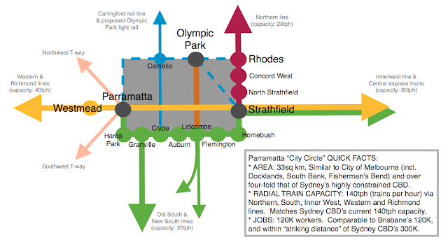
Parramatta's "city circle": world class ring of CBD train stations

Parramatta CBD is so much overshadowed by the Sydney CBD that it's characteristics as a CBD in it's own right are under-appreciated.  I believe the biggest reason of the "under-marketing" of Parramatta CBD is that it is seen only through the lens of the high rise building zone around Parramatta railway station - whereas both Melbourne and Sydney CBD have the concepts of a "city circle" or "city loop" of 8+ train stations.  Also, the boundaries of the Parramatta local government area are nonsensical, incorporating suburban areas far to the north of Parramatta River (bordering onto Hornsby LGA) whilst missing out on immediately adjacent employment zones like Silverwater and Olympic Park that are south of Parramatta River.

So it's important to redefine the conventional notion of Parramatta CBD.  It needs to be more than a highrise zone around a single train station.  It needs to incorporate diverse and vibrant precincts in the same way Sydney CBD has districts like Ultimo, Pyrmont, Darlinghurst that add character to the high rise business core.

The catch is therefore broadening out the definition of Parramatta CBD to the corridor contained within the "city circle" of train stations between Westmead, Strathfield and Rhodes:


This definition is important, as Parramatta station precinct on it's own is not in the "world class" league.  However, Parramatta "city circle" is clearly world-class as highlighted in the poster below: